MapMyIndia Launches Digital Twin Of Real World

Highlights
- Strategic alliances with ISRO, Idea Cellular, Udacity India
- MapMyIndia acquires VidTeq, a pioneer in Video Maps
- 360 degree, 3D digital map announced
India's leader in premium-quality digital maps, GPS navigation, GPS tracking, location-based apps and GIS solutions, MapMyIndia also announced alliances with Indian Space Research Organisation (ISRO), Idea Cellular , Visit Health, Aatapaha Smart Lighting, Reverie Language Technologies and Udacity India, to develop India-specific solutions. MapMyIndia offers India's best maps and location technologies to ISRO, including ISRO's satellite mapping portal, Bhuvan. ISRO has recently launched NAVIC, India's indigenous satellite navigation system. MapMyIndia also announced the acquisition of VidTeq, a pioneer in VideoMaps.
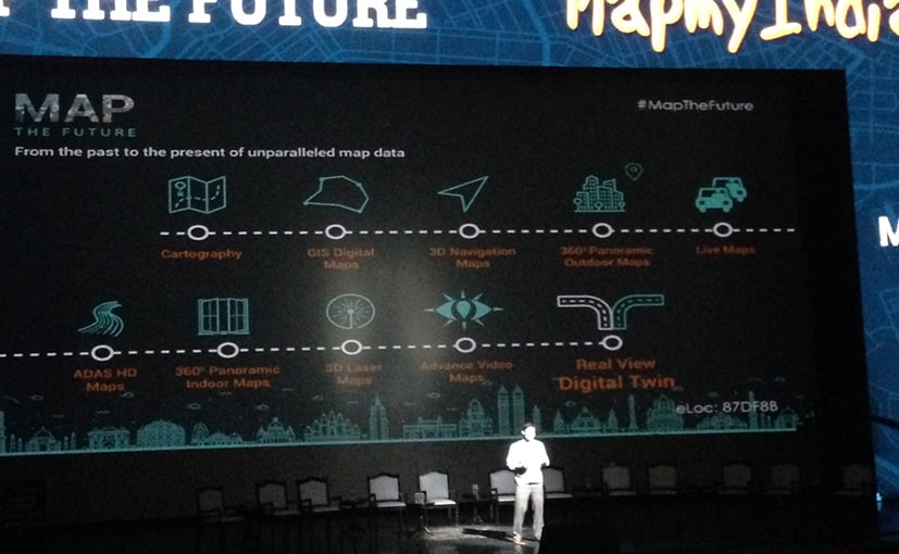
ISRO's Bhuvan, MapMyIndia's Maps and NAVIC have all been integrated for the most powerful, indigenous joint solution of space, ground and satellite mapping and navigation technologies. MapMyIndia has already built a fisherman and coast guard alert app to help prevent fishermen from straying beyond Indian waters through the tracking and geo-fencing features in its new Map app. In its flagship "Map the Future" conference, MapMyIndia announced the development of what is called the Digital Twin of the Real World.
"The next generation of our revolutionary Real View service, wherein we are pioneering building of the first Digital Map Twin of the Real World, powered by our technology building and acquisition efforts, is unprecedented, universal and overarching. It will be an all India map of the outdoor and indoor, in 360 degree and 3D, highly accurate and updated live, available in all local languages, captured from the ground as well as the skies, where each place and object is given a unique, simple, standardized identity, that we call eLoc," said Rohan Verma, Chief Technology Officer, MapMyIndia.

MapMyIndia Map the Future Conference
The company also unveiled a series of ground-breaking map and location-based technology and product releases. The Map app has what is called the "eLoc" feature. eLoc is a unique six digit code for any location, which can be mapped or shared by users. MapMyIndia has also launched a new language-based intelligent keyboard app, with built-in map intelligence and assistance, called HeyMap. All these solutions will be available as "best for India" solutions, for over 120 crore Indians, more than 5 crore Indian businesses, as well as over 7 lakh Indian governments, from village to municipal to district to state to central level, a statement from the company said.
Latest News
- Home
- News
- Technology
- MapMyIndia Launches Digital Twin Of Real World


